


Geospatial Data-Based Predictive Modelling of Landslide Events
This comprehensive analysis examines the state-of-the-art approaches in geospatial data-based predictive modelling of landslide events, synthesizing findings from over 40 recent studies spanning multiple continents and diverse geological settings. The integration of advanced machine learning algorithms, remote sensing technologies, and Geographic Information Systems (GIS) has revolutionized landslide susceptibility assessment, enabling more accurate predictions and effective risk management strategies. Current research demonstrates that ensemble methods, particularly those combining deep learning architectures with traditional statistical approaches, achieve prediction accuracies exceeding 95% in optimal conditions, with Convolutional Neural Networks (CNNs) and Random Forest algorithms emerging as the most robust techniques for complex terrain analysis.
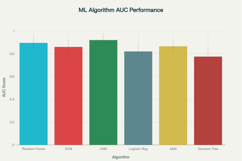
Performance comparison of machine learning algorithms for landslide susceptibility mapping based on AUC values from multiple research studies
Data Sources and Geospatial Technologies
Remote Sensing and Digital Elevation Models
The foundation of modern landslide prediction systems relies heavily on high-quality geospatial data acquisition through various remote sensing platforms. Digital Elevation Models (DEMs) serve as the cornerstone for terrain analysis, with studies consistently demonstrating that DEM quality significantly impacts model performance. Research comparing different DEM sources reveals that TanDEM-X DEMs at 12-meter resolution outperform traditional ASTER and SRTM products, achieving median Area Under the Receiver Operating Characteristics Curve (AUROC) values of 0.708-0.730 compared to 0.568-0.595 for ASTER-based models.
Light Detection and Ranging (LiDAR) technology has emerged as a transformative tool for landslide detection and monitoring, particularly in forested areas where optical imagery proves inadequate. Multi-source remote sensing approaches combining UAV-LiDAR, satellite interferometric synthetic aperture radar (InSAR), and digital photogrammetry provide comprehensive datasets for analyzing landslide characteristics. A notable case study in Gokseong County, South Korea, demonstrated the effectiveness of this integrated approach, where UAV-LiDAR data revealed eroded and deposited landslide volumes of approximately 5.60 × 10⁴ m³ and 1.58 × 10⁴ m³, respectively.
Satellite imagery processing has become increasingly sophisticated, with high-resolution platforms like WorldView, SPOT-5, and Landsat providing multi-spectral data essential for landslide susceptibility mapping. Advanced processing techniques extract critical parameters including vegetation indices (NDVI), land use classifications, and geological features that serve as predictor variables in machine learning models.
Conditioning Factors and Spatial Variables
Contemporary landslide prediction models integrate multiple conditioning factors derived from diverse geospatial data sources. Topographical factors derived from DEMs include slope angle, elevation, aspect, curvature, and topographic wetness index, which collectively account for the primary geometric controls on slope stability. Research indicates that slope angle emerges as the most significant predictor, with importance scores consistently ranking above 9.0 on a 10-point scale across multiple studies.
Geological and hydrological factors encompass lithology, soil properties, distance to rivers and fault lines, and drainage density. These parameters capture the material properties and structural controls that influence landslide susceptibility. Studies in the Ethiopian highlands demonstrate that lithology and distance to streams significantly influence landslide occurrence, with weathered volcanic rocks showing particular susceptibility under heavy rainfall conditions.
Environmental and anthropogenic factors include rainfall patterns, land use changes, distance to roads, and vegetation characteristics. Climate data integration has become increasingly critical, with research showing that accumulated rainfall exceeding 250mm over 2-3 day periods serves as a primary trigger for landslide initiation. Human activities, particularly road construction and deforestation, significantly alter natural slope stability, necessitating their inclusion in comprehensive prediction models.
Machine Learning and Deep Learning Approaches
Traditional Statistical Methods
Frequency Ratio (FR) and Weights of Evidence (WoE) models represent established bivariate statistical approaches that analyze the spatial relationship between landslide occurrences and conditioning factors. Ethiopian case studies demonstrate FR model superiority over WoE methods, achieving prediction accuracies of 88.2% compared to 84.8%. These methods provide interpretable results and require minimal computational resources, making them suitable for regions with limited technical infrastructure.
Logistic Regression (LR) remains a fundamental approach for landslide susceptibility assessment due to its statistical robustness and interpretability. Iranian studies utilizing LR for the Sajarood basin achieved satisfactory prediction performance while identifying proximity to roads as the strongest predictor of landslide occurrence. However, LR models typically achieve lower accuracies (75-89% AUC) compared to advanced machine learning approaches.
Advanced Machine Learning Algorithms
Random Forest (RF) algorithms demonstrate exceptional performance across diverse geographical settings, consistently achieving AUC values above 0.90 in well-designed studies. The algorithm’s ability to handle high-dimensional datasets, capture non-linear relationships, and provide feature importance rankings makes it particularly suitable for landslide prediction. Brazilian studies in Petrópolis achieved remarkable performance with RF models, recording accuracy of 0.94, ROC AUC of 0.98, and F1 score of 0.94.
Support Vector Machines (SVM) excel in handling complex, non-linear classification problems and demonstrate robust performance in landslide susceptibility mapping. Research comparing SVM with other algorithms shows consistent performance with AUC values ranging from 0.80 to 0.92, making them reliable alternatives when interpretability is less critical than predictive accuracy.
Artificial Neural Networks (ANN) and their variants have gained prominence for their ability to capture complex spatial patterns and non-linear relationships between conditioning factors. Bangladeshi studies developing early warning systems for Chittagong Metropolitan Area found ANN models superior to multiple regression and principal component analysis methods for rainfall-induced landslide prediction.
Deep Learning Innovations
Convolutional Neural Networks (CNNs) represent the cutting edge of landslide prediction technology, achieving unprecedented accuracies in recent studies. Iranian research in the Bakhtegan watershed demonstrated CNN model superiority with 95.76% accuracy and 95.11% precision, significantly outperforming traditional classification approaches. CNNs excel at automatically extracting spatial features from multi-dimensional geospatial data, learning intricate patterns that influence slope instability without manual feature engineering.
Recurrent Neural Networks (RNNs) and Long Short-Term Memory (LSTM) networks address temporal aspects of landslide prediction by incorporating time-series data such as rainfall patterns and ground displacement measurements. Thai studies implementing Bidirectional LSTM (Bi-LSTM) algorithms combined with Random Forest achieved superior performance over traditional approaches, with AUC improvements of 0.42-0.47 compared to linear regression and standard neural networks.
Ensemble and Hybrid Methods
Stacking and Blending Approaches
Ensemble learning techniques combine multiple base models to improve prediction accuracy and reduce overfitting risks. Chinese studies in the Bailong River Basin demonstrate that stacking ensemble methods utilizing multilayer perceptron, CNN, and gated recurrent unit models as base learners achieve AUC values of 0.88, outperforming individual models. These approaches address the limitation that no single algorithm universally excels across all geographical settings and landslide types.
Boosting and Bagging techniques enhance individual model performance through iterative training and parallel ensemble construction. Research shows that LR-MLP-Boosting models achieve the highest prediction accuracy with 43.75% of landslide pixels concentrated in very high susceptibility areas, demonstrating superior discrimination capability.
Optimization-Enhanced Models
Electromagnetic Field Optimization (EFO) coupled with multilayer perceptron networks represents innovative approaches to hyperparameter optimization in landslide prediction. Iranian studies in Ardal County demonstrate that EFO-MLP ensembles provide fast convergence and powerful optimization capabilities while maintaining high prediction accuracy.
Positive-Unlabeled (PU) learning methodologies address the challenge of imbalanced datasets common in landslide studies, where non-landslide samples significantly outnumber landslide occurrences. Himalayan studies pioneering PU learning applications demonstrate more conservative and reliable susceptibility mapping, crucial for regions where false negatives could lead to catastrophic consequences.
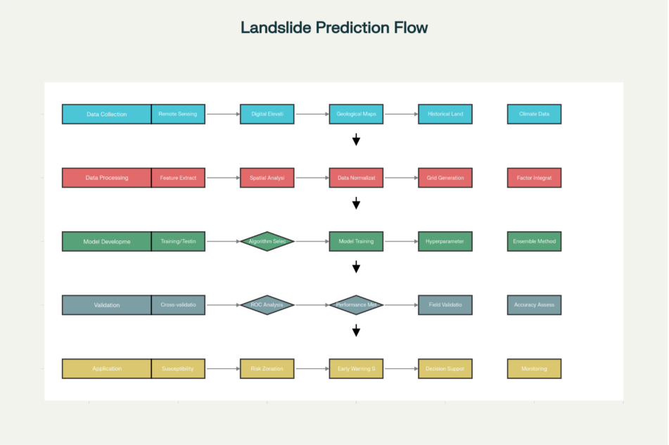
Comprehensive methodology flowchart for geospatial data-based landslide predictive modeling
Validation and Performance Assessment
Statistical Validation Metrics
Receiver Operating Characteristic (ROC) analysis and Area Under the Curve (AUC) calculations serve as primary validation tools for landslide susceptibility models. Research standards indicate that AUC values above 0.80 represent good model performance, while values exceeding 0.90 indicate excellent predictive capability. Comprehensive studies comparing multiple algorithms consistently show deep learning approaches achieving the highest AUC scores, with CNNs averaging 0.92 across diverse geographical settings.
Confusion matrix analysis provides detailed insights into model performance through true positive, true negative, false positive, and false negative classifications. Advanced metrics including precision, recall, F1-score, and Matthews Correlation Coefficient offer comprehensive performance assessment beyond simple accuracy measures. Iranian CNN studies demonstrate the importance of multiple validation metrics, achieving Mean Absolute Error (MAE) of 0.11864, Mean Squared Error (MSE) of 0.18796, and Root Mean Squared Error (RMSE) of 0.18632.
Spatial and Temporal Validation
Cross-validation techniques address the challenge of spatial autocorrelation in landslide data through careful partitioning strategies that maintain geographical independence between training and testing datasets. Studies typically employ 70-30 or 80-20 training-testing splits while ensuring spatial distribution representativeness across the study area.
Landslide Density Index (LDI) validation compares the ratio of landslide occurrence percentages to area percentages within each susceptibility class. Successful models demonstrate increasing LDI values from low to high susceptibility zones, with Ethiopian studies showing LDI values of 2.743 and 2.993 for very high susceptibility classes using WoE and FR models, respectively.
Real-World Applications and Case Studies
Early Warning Systems
Web-GIS based landslide early warning systems represent practical implementations of predictive models for disaster risk reduction. The Chiang Rai, Thailand system demonstrates successful integration of machine learning models with real-time rainfall APIs and Google Maps visualization, providing automated landslide risk alerts five days in advance via email notifications. This system combines static susceptibility maps with dynamic rainfall thresholds using a purposely-built hazard matrix approach.
Regional forecasting systems operate at multiple spatial scales, from local catchment-level predictions to national-scale assessments. Indian initiatives by the Geological Survey of India encompass 10 states with operational and developmental phases extending through 2030, incorporating satellite-derived rainfall data and ground-based monitoring systems for comprehensive landslide management.
Infrastructure and Urban Planning Applications
Critical infrastructure protection utilizes landslide susceptibility maps for strategic placement of transportation networks, utilities, and residential developments. Italian Alpine studies demonstrate GIS-based spatial analysis models supporting land-use planning and risk management through identification of various susceptibility classes and main conditioning factors.
Post-disaster recovery planning leverages volume estimation capabilities of LiDAR-based systems for hydrogeomorphic alteration assessment and reconstruction strategies. South Korean case studies show how multi-source remote sensing provides precise quantification of landslide magnitude, facilitating effective recovery plan formulation.
Monitoring and Risk Assessment
Real-time monitoring systems integrate wireless sensor networks, Internet of Things (IoT) technologies, and satellite-based observations for continuous landslide threat assessment. These systems address limitations of traditional prediction methods by providing dynamic updates based on changing environmental conditions and ground displacement measurements.
Vulnerability assessment frameworks combine landslide susceptibility with exposure analysis of population, infrastructure, and economic assets to quantify potential losses. This comprehensive approach supports evidence-based decision-making for resource allocation and mitigation strategy prioritization across large geographical regions.
Challenges and Limitations
Data Quality and Availability
Heterogeneous data sources present significant integration challenges, requiring advanced data fusion techniques and standardization protocols. Studies consistently identify the need for detailed soil properties, geology, and hydrogeological data as primary limitations constraining model accuracy and reliability. Remote and mountainous regions often lack comprehensive ground-truth data, necessitating innovative sampling strategies and remote sensing solutions.
Temporal data scarcity limits the development of robust time-series models, particularly for regions with limited historical landslide records. Climate change impacts introduce additional uncertainty, as future landslide patterns may deviate significantly from historical trends used for model training.
Model Transferability and Generalization
Geographical transferability remains a critical challenge, as models trained in specific geological and climatic settings often perform poorly when applied to different regions. Research indicates that optimal algorithms and factor combinations vary significantly across study areas, necessitating location-specific model development and validation.
Scale dependency affects model performance, with optimal spatial resolutions varying based on landslide characteristics and study objectives. Fine-scale models may capture local features but require extensive computational resources, while coarse-scale applications may miss critical terrain variations.
Technical and Institutional Barriers
Computational requirements for advanced deep learning models may exceed available resources in developing regions, limiting widespread implementation of state-of-the-art techniques. Model interpretability challenges with complex algorithms create difficulties for stakeholder acceptance and decision-making integration.
Real-time implementation faces technical, logistical, and institutional barriers including sensor network maintenance, data transmission reliability, and inter-agency coordination requirements. Successful systems require sustained technical support and institutional commitment extending beyond initial development phases.
Future Directions and Recommendations
Technological Advancements
Artificial Intelligence integration shows promise through explainable AI methods that enhance model transparency while maintaining high prediction accuracy. Future research should prioritize interpretable machine learning approaches that balance performance with stakeholder understanding requirements.
Multi-temporal analysis capabilities using satellite time-series data offer opportunities for detecting pre-failure displacement and improving prediction lead times. Integration of persistent scatterer interferometry and advanced change detection algorithms may enable earlier landslide warning capabilities.
Data Integration and Standardization
Global data sharing initiatives could address data scarcity challenges through coordinated international efforts to establish comprehensive landslide databases. Standardized data collection protocols and metadata frameworks would facilitate model comparison and transferability assessment across different regions.
Crowdsourcing and citizen science approaches may supplement traditional data collection methods, particularly for rapid post-event damage assessment and inventory updating. Mobile-based applications enabling real-time hazard reporting by local communities could enhance monitoring network coverage and response capabilities.
Interdisciplinary Collaboration
Cross-sectoral partnerships between researchers, practitioners, and stakeholders from geology, engineering, computer science, and emergency management fields are essential for developing practical and effective landslide prediction systems. Academic-industry collaborations should focus on bridging the gap between research innovations and operational implementation requirements.
Conclusion
Geospatial data-based predictive modeling of landslide events has evolved into a sophisticated interdisciplinary field combining advanced remote sensing, machine learning algorithms, and comprehensive validation frameworks. Contemporary research demonstrates that ensemble methods integrating multiple data sources and algorithmic approaches achieve superior performance compared to single-model implementations, with the most successful systems reaching prediction accuracies exceeding 95%. The integration of deep learning architectures, particularly CNNs and LSTM networks, with traditional statistical methods provides robust solutions for complex terrain analysis and temporal pattern recognition.
The effectiveness of landslide prediction systems depends critically on data quality, with high-resolution DEMs and multi-source remote sensing platforms serving as essential foundations for accurate susceptibility assessment. Successful implementations require careful consideration of local geological, climatic, and anthropogenic factors, emphasizing the need for region-specific model development and validation protocols. Early warning systems integrating real-time monitoring capabilities with predictive models demonstrate significant potential for disaster risk reduction, though implementation challenges including data availability, computational requirements, and institutional coordination must be addressed.